
Topic: Development Of Landscape Features
Development Of Landscape Features
Mendon Ponds Park
Mendon Ponds Park, in New York State, is listed in the National Registry of National Landmarks due to its outstanding glacial landscape features. Glacial ice that covered most of New York State retreated northward at the end of the last ice age. As this glacial ice melted, great amounts of sediments were deposited at the glacier’s southern edge. Four glacial features dominate the park’s landscape. Kettles are bowl-shaped depressions formed when buried blocks of glacial ice melt. If the depressions fill with water, they are called kettle lakes. The Mendon Park ponds are all kettle lakes. Eskers are ridges of sorted sediments deposited within streams flowing beneath the melting glacier. Kames are small hills of unsorted sediment deposited at the base of waterfalls formed by streams flowing over the edge of a melting glacier.
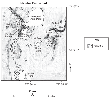
Based on the map, in which New York State landscape region is Mendon Ponds Park located?
(1) Allegheny Plateau
(2) Tug Hill Plateau
(3) Erie-Ontario Lowlands
(4) Hudson-Mohawk Lowlands
A plane traveling in a straight line from Watertown to Utica would fly over which landscape region?
(1) Tug Hill Plateau
(2) Adirondack Mountains
(3) St. Lawrence Lowlands
(4) Champlain Lowlands
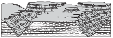
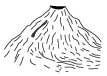
The block diagram below shows a volcano.

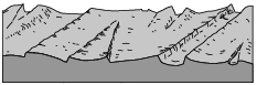
Which map shows the stream drainage pattern that most likely formed on the surface of this volcano?
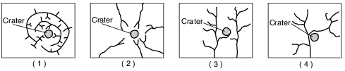
(1) 1
(2) 2
(3) 3
(4) 4
The Catskills landscape region is classified as a plateau because it has
(1) low elevations and mostly faulted or folded bedrock
(2) low elevations and mostly horizontal bedrock
(3) high elevations and mostly faulted or folded bedrock
(4) high elevations and mostly horizontal bedrock
Stream drainage patterns that develop in a landscape region are controlled mostly by
(1) bedrock structure
(2) precipitation amounts
(3) nearness to a large body of water
(4) air temperature variations
Which cross section best represents a plateau landscape region?

(1) 
(2) 
(3) 
(4) 
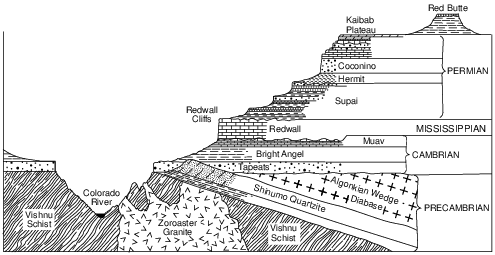
The Marcellus Shale
The Marcellus shale is a black shale formation that was formed during the Middle Devonian Period. The shale extends from New York State as far south as Alabama. The Marcellus shale is exposed at the surface in the northern Finger Lakes region, and is buried 2.1 kilometers below the surface along the New York-Pennsylvania border.
Geologists estimate that the Marcellus shale contains hundreds of trillions of cubic feet of natural gas. Most of the Marcellus shale does not allow fluids (gases and liquids) to flow through the rock. In order to obtain the natural gas trapped in the rock, the shale is fractured. This hydraulic fracturing consists of drilling a well, then pumping in large amounts of water containing chemicals and sand under high pressure to create cracks in the gas-bearing rock. Although this process can allow the trapped gas to be removed from the shale, opponents of hydraulic fracturing argue that the chemicals used in the process may lead to groundwater contamination.
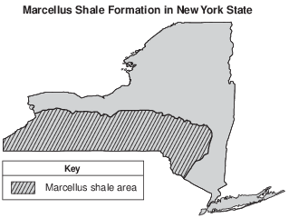
In New York State, the Marcellus shale is generally found in which type of landscape region?
(1) plain
(2) plateau
(3) mountains
(4) lowlands
Which climate conditions most likely produce a landscape with rounded hills, large river valleys with many tributaries, and tropical vegetation?
(1) cool and arid
(2) cool and humid
(3) warm and arid
(4) warm and humid
The Genesee River flows across both the Allegheny Plateau and the Erie-Ontario Lowlands in New York State. This river flows
(1) northward, in the same general direction as the Hudson River
(2) northward, in the same general direction as the Niagara River
(3) southward, in the same general direction as the Hudson River
(4) southward, in the same general direction as the Niagara River
If the climate of the Grand Canyon region became more humid, the rate of weathering and erosion would most likely
(1) decrease, and the landscape features would become more rounded
(2) decrease, and the landscape features would become more angular
(3) increase, and the landscape features would become more rounded
(4) increase, and the landscape features would become more angular
The diagram below represents a volcano.
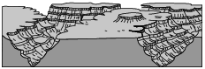
Which stream drainage pattern would most likely form on the entire surface of this volcano?
(1) 
(2) 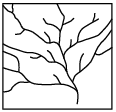
(3) 
(4) 
The Tug Hill region of New York State is geologically classified as a plateau because this region has relatively
(1) high elevation and deformed bedrock
(2) low elevation and deformed bedrock
(3) high elevation and horizontal bedrock
(4) low elevation and horizontal bedrock
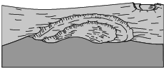
Which diagram below best represents the surface features developed in a humid climate?
(1) 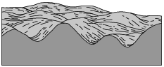
(2) 
(3) 
(4) 

Describe one characteristic of the coastal plain that caused the river to develop meanders. [1]
Allow 1 credit. Acceptable responses include, but are not limited to:
• — The slope is less steep.
• — gentle slope
• — The land is nearly flat.
The Niagara Escarpment
A prominent feature found along the shore of Lake Ontario in western New York State is the Niagara Escarpment. This escarpment is the remains of an ancient seabed that was formed when the area was covered by a warm, shallow sea from approximately450 to 430 million years ago. Erosion of the Taconic Mountains to the east provided
the sediments deposited in this basin area. From these sediments, rock layers such as shale, sandstone, and limestone formed. Later, magnesium replaced some of the calcium in the top layer of limestone, turning it into a dolostone layer. When the high ocean levels of the Ordovician Period dropped, the draining of this inland sea caused unequal erosion of the exposed layers. The South Moraine was deposited on the top of the Niagara Escarpment in this region.
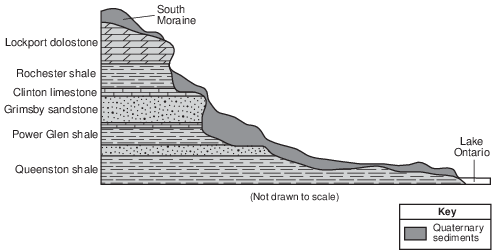
Identify the New York State landscape region in which the Niagara Escarpment is located. [1]
Allow 1 credit for Erie-Ontario Lowlands, or Erie-Ontario Plains, or Interior Lowlands.