
Topic: Earthquake P Wave And S Wave Travel Time
Earthquake P Wave And S Wave Travel Time
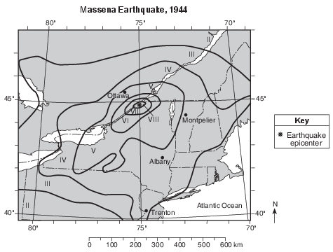
How long did it take for the first P-wave to travel from the epicenter of this earthquake to a seismic station in Trenton, New Jersey?
(1) 1 minute 10 seconds
(2) 2 minutes 10 seconds
(3) 3 minutes 20 seconds
(4) 4 minutes 20 seconds
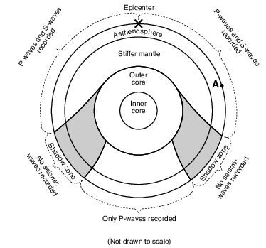
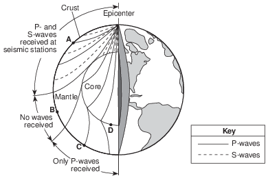
How many kilometers did the seismic waves travel from the earthquake directly to the outside of the outer core?
(1) 800 km
(2) 1400 km
(3) 2900 km
(4) 6400 km
A seismic recording station located 4000 kilometers from the epicenter of an earthquake received the first P-wave at 7:10:00 p.m. (h:min:s). Other information that could be determined from this recording was that the earthquake occurred at approximately
(1) 7:03:00 p.m., and the S-wave arrived at this station at 7:12:40 p.m.
(2) 7:03:00 p.m., and the S-wave arrived at this station at 7:15:40 p.m.
(3) 7:17:00 p.m., and the S-wave arrived at this station at 7:12:40 p.m.
(4) 7:17:00 p.m., and the S-wave arrived at this station at 7:15:40 p.m.
A seismic P-wave is recorded at 2:25 p.m. at a seismic station located 7600 kilometers from the epicenter of an earthquake. At what time did the earthquake occur?
(1) 2:05 p.m.
(2) 2:11 p.m.
(3) 2:14 p.m.
(4) 2:36 p.m.
The epicenter of an earthquake is located6500 kilometers away from a seismic station.
If the first S-wave arrived at this seismic station at 1:30 p.m., at what time did the first P-wave arrive?
(1) 1:20 p.m.
(2) 1:22 p.m.
(3) 1:38 p.m.
(4) 1:40 p.m.
If it takes a P-wave five minutes to travel from the epicenter of an earthquake to a seismic station, approximately how long will it take an S-wave to travel that same distance?
(1) 15 minutes
(2) 12 minutes
(3) 9 minutes
(4) 4 minutes
What is the approximate time difference between the first P-wave and the first S-wave recorded at a seismic station located 8000 kilometers from an earthquake’s epicenter?
(1) 8 minutes 40 seconds
(2) 9 minutes 20 seconds
(3) 11 minutes 20 seconds
(4) 20 minutes 40 seconds
If a seismic station is 3200 km from an earthquake epicenter, what is the time needed for an S-wave to travel from the epicenter to the seismic station?
(1) 4 min 40 sec
(2) 6 min 0 sec
(3) 10 min 40 sec
(4) 11 min 10 sec
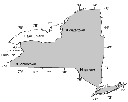
Compared to the time of sunrise in Kingston, the time of sunrise in Jamestown would be approximately
(1) 1 hour earlier
(2) 1 hour later
(3) 20 minutes earlier
(4) 20 minutes later
What is the approximate P-wave travel time from an earthquake if the P-wave arrives at the seismic station 8 minutes before the S-wave?
(1) 4 minutes 20 seconds
(2) 6 minutes 30 seconds
(3) 10 minutes 0 seconds
(4) 11 minutes 20 seconds
Seismic station A is 5000 kilometers from the epicenter. What is the difference between the arrival time of the first P-wave and the arrival time of the first S-wave recorded at this station?
(1) 2 minutes 20 seconds
(2) 6 minutes 40 seconds
(3) 8 minutes 20 seconds
(4) 15 minutes 00 second
Tsunami Capital
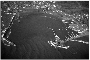
The tsunami capital of the continental United States is Crescent City, located on the coast in northern California. Since 1933, thirty-one tsunamis have been observed there. Crescent City is vulnerable to tsunamis because of the low elevation of the land and the shape of its shoreline. The wave energy from a tsunami is funneled into a narrow stretch of shoreline. This causes the wave height to grow very tall, fl ooding more land. The largest and most destructive tsunami to hit Crescent City occurred in March 1964, killing eleven people. The epicenter of a very large earthquake, located at 60° N and 147° W, caused this destructive tsunami.
The distance from the epicenter of the March 1964 earthquake to Crescent City is 2600 kilometers. How long did it take the fi rst P-wave to reach Crescent City?
(1) 3 minutes 20 seconds
(2) 4 minutes 10 seconds
(3) 5 minutes 0 seconds
(4) 9 minutes 10 seconds
An earthquake occurs at 10:05 a.m. At 10:09 a.m., the first P-wave from this earthquake is detected at a seismic station. Approximately how many kilometers (km) from the epicenter is this seismic station located?
(1) 1000 km
(2) 2000 km
(3) 2600 km
(4) 5600 km
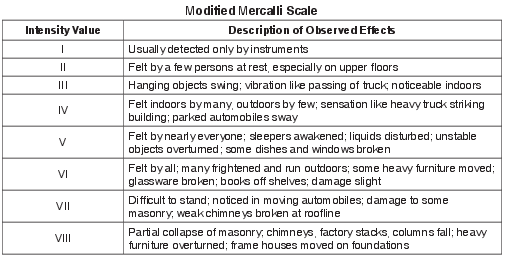
Adirondack Earthquake
On October 7, 1983, a magnitude 5.3 earthquake occurred in New York State’s Adirondack region. The earthquake’s epicenter was at Blue Mountain Lake, which is located approximately 32 miles (50 kilometers) southwest of Mt. Marcy.
Determine how long it took the first P-wave to travel from Blue Mountain Lake to a seismic station1200 kilometers away. [1]
________ min ________ s
Allow 1 credit for any value from 2 min 30 s to 2 min 40 s.

Describe one way the P-waves and S-waves recorded on seismograms at Ishinomaki and Nagano were used to indicate that Ishinomaki was closer to the earthquake epicenter than was Nagano. [1]
Allow 1 credit. Acceptable responses include, but are not limited to:
• — P-waves arrived earlier at Ishinomaki than at Nagano.
• — The difference in arrival times was less at Ishinomaki.
• — The P-wave and S-wave arrival time interval was greater at Nagano.
• — The amplitude/magnitude of seismic waves was greater/bigger/stronger at Ishinomaki.
• — There is less time difference between the P- and S-waves at the closer location.
• — P- and S-waves were closer together.