
Topic: Effect Of Vertical Atmospheric Movement
Effect Of Vertical Atmospheric Movement
During which month does the Sun rise north of due east in New York State?
(1) February
(2) July
(3) October
(4) December
The cross section below shows two cities, A and B, at different elevations.

Compared to the yearly temperature and precipitation at city B, city A most likely has
(1) lower temperatures and less precipitation
(2) lower temperatures and more precipitation
(3) higher temperatures and less precipitation
(4) higher temperatures and more precipitation
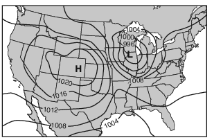
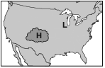
Which map shows the most likely location of clouds associated with these pressure centers?
(1) 
(2) 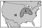
(3) 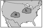
(4) 
Which sequence of events affecting moist air within Earth’s atmosphere causes cloud formation?
(1) rising → expanding → cooling → condensation
(2) rising → contracting → warming → evaporation
(3) sinking → expanding → warming → condensation
(4) sinking → contracting → cooling → evaporation
The cross section below represents a prevailing wind flow that causes different climates on the windward and leeward sides of a mountain range.

Compared to the temperature and moisture of the air rising on the windward side, the temperature and moisture of the air descending at the same altitude on the leeward side will be
(1) warmer and drier
(2) warmer and more moist
(3) cooler and drier
(4) cooler and more moist
Clouds most likely form as a result of
(1) moist air rising, compressing, and warming
(2) moist air rising, expanding, and cooling
(3) dry air rising, compressing, and warming
(4) dry air rising, expanding, and cooling
Most clouds form in the atmosphere when moist air
(1) rises, expands, and cools to the dewpoint
(2) rises, expands, and warms to the dewpoint
(3) sinks, compresses, and cools to the dewpoint
(4) sinks, compresses, and warms to the dewpoint
Clouds are formed when moist, rising air
(1) contracts and cools, and water vapor condenses
(2) contracts and warms, and water evaporates
(3) expands and cools, and water vapor condenses
(4) expands and warms, and water evaporates
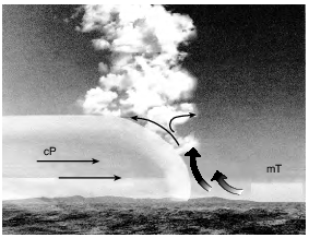
Clouds are forming along the front because the rising air is
(1) contracting and warming, causing evaporation
(2) contracting and cooling, causing evaporation
(3) expanding and warming, causing condensation
(4) expanding and cooling, causing condensation
This storm occurred while Lake Ontario was not frozen. Explain why snowfall amounts would have been less if the lake had had significant ice cover. [1]
Allow 1 credit. Acceptable responses include, but are not limited to:
• — Not as much moisture would have evaporated from Lake Ontario, so the snowfall depths
• would not have been as great.
• — Less water vapor would have been picked up from the lake surface.
• — An unfrozen lake surface allows for more evaporation.
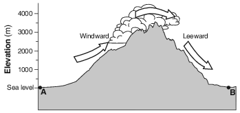
Explain why air cools as it rises up this mountain. [1]
Allow 1 credit. Acceptable responses include, but are not limited to:
• — Air expands as it moves up the mountain.
• — The molecules move farther apart as the air rises.
• — Lower pressure at higher altitudes allows molecules to move farther apart.
• — The less dense air at higher altitudes allows the air molecules to spread out.
Identify one process that occurred in rising, moist air that caused the clouds to form at this location. [1]
Allow 1 credit. Acceptable responses include, but are not limited to:
• — expansion
• — condensation
• — cooling
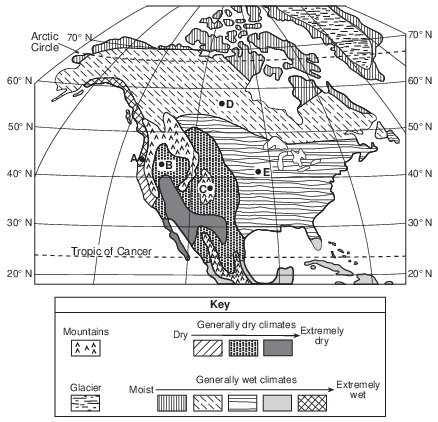
Explain why the climate at location A is more moist than the climate at location B. [1]
Allow 1 credit. Acceptable responses include, but are not limited to:
• — Location A is on the windward side of mountains.
• — Location A receives prevailing winds off the ocean.
• — Location A is closer to the ocean.
• — Location B is on the leeward side of a mountain range.
• — Adiabatic warming occurs in descending air at location B after losing most of its moisture
• on the windward side of a mountain/orographic effect.
• — The prevailing southwest winds bring moist air to location A.
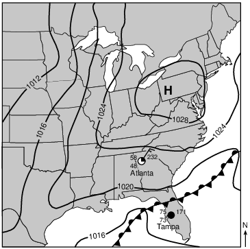
Describe one piece of evidence shown on the map that indicates that Tampa, Florida, has a high probability of precipitation. [1]
Allow 1 credit. Acceptable responses include, but are not limited to:
• — The dewpoint and air temperature are close together./high relative humidity
• — 100% cloud cover/overcast
• — Tampa is close to a front.
• — The air pressure is low.
The map below shows the locations of three volcanoes on the island of Hawaii. The arrows represent the direction of the planetary winds. Points X and Y represent surface locations on the island.

Explain why location X usually receives less annual precipitation than location Y. [1]
Allow 1 credit. Acceptable responses include, but are not limited to:
• — Location X is located on the leeward side of a mountain.
• — Location X is located on the rain shadow side of a mountain.
• — Location Y is located on the windward side of a mountain.
• — Moist air rises over location Y, resulting in precipitation.
• — orographic effect
• — A mountain/volcano barrier separates X and Y.
• — Planetary winds bring moisture to location Y, but lack this moisture by the time they get to
• location X.
• — Location X is farther from the ocean.