Earth Science worksheet
    Topic: Generalized Bedrock Geology Of New York State
    Generalized Bedrock Geology Of New York State
    1

    Which type of surface bedrock is most commonly found in the Utica, New York area?

    (1) sedimentary, with limestone, shale, sandstone, and dolostone

    (2) sedimentary, with limestone, shale, sandstone, and conglomerate

    (3) metamorphic, with quartzite, dolostone, marble, and schist

    (4) metamorphic, with gneiss, quartzite, marble, and slate

    Base your answers to questions 2 on the graph below and on your knowledge of Earth science. The graph shows the observed water levels, in feet (ft), for a tide gauge located at Montauk, New York, on the easternmost end of Long Island, from January 24, 2008 to noon on January 25, 2008.

    seasons-and-astronomy, tides, seasons-and-astronomy, motion-of-objects-in-the-solar-system, standard-1-math-and-science-inquery, velocity-slope-sediment-size-channel-shape-stream-valume-distance-from-the-sun-gravitational-force-period-of-revolution-speed-of-revolution, standard-6-interconnectedness, models fig: esci62018-examw_g51.png

    2

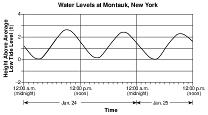
    What is the approximate latitude and longitude of the tide gauge?

    (1) 40°30' N 72°00' W

    (2) 40°30' N 74°00' W

    (3) 41°00' N 72°00' W

    (4) 41°00' N 74°00' W

    Base your answers to questions 3 on the map below and on your knowledge of Earth science. The map shows the locations of major watersheds in New York State. Letters A through K represent individual watersheds.

    reference-tables, generalized-bedrock-geology-of-new-york-state, landscapes, development-of-landscape-features, standard-1-math-and-science-inquery, changing-length-of-a-shadow-based-on-the-motion-of-the-sun, standard-6-interconnectedness, models fig: esci82016-examw_g30.png

    3

    In which major watershed is the Susquehanna River located?

    (1) F

    (2) H

    (3) I

    (4) J

    4

    The map below shows the locations of some oil and gas fields in New York State.

    reference-tables, generalized-bedrock-geology-of-new-york-state, reference-tables, sedimentary-rock-identification, rocks-and-minerals, formation-classification-and-application-of-rocks, standard-1-math-and-science-inquery, changing-length-of-a-shadow-based-on-the-motion-of-the-sun, standard-6-interconnectedness, models fig: esci82018-examw_g32.png

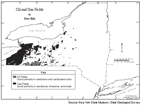
    Which type of bedrock contains these oil and gas deposits?

    (1) extrusive igneous rock

    (2) intrusive igneous rock

    (3) metamorphic rock

    (4) sedimentary rock

    5

    The map below shows the present-day positions of the continents. Points A through D represent locations on Earth’s surface. The location of New York State on the North American continent is indicated.

    reference-tables, generalized-bedrock-geology-of-new-york-state, earth-history, earth-history, geologic-time-units-and-the-events, dynamic-earth, global-changes-resulted-from-plate-motions, earth-history, changes-resulted-from-plates-motion, standard-1-math-and-science-inquery, changing-length-of-a-shadow-based-on-the-motion-of-the-sun, standard-6-interconnectedness, models, standard-6-interconnectedness, patterns-of-change fig: esci62017-exampwr_g13.png

    Which letter best represents the inferred position of the New York State region on Earth at the end of the Devonian Period?

    (1) A

    (2) B

    (3) C

    (4) D

    6

    The map below shows the average annual snowfall, in inches, for western New York State.

    reference-tables, generalized-bedrock-geology-of-new-york-state, meteorology, presentation-of-weather-data, standard-1-math-and-science-inquery, velocity-slope-sediment-size-channel-shape-stream-valume-distance-from-the-sun-gravitational-force-period-of-revolution-speed-of-revolution, standard-1-math-and-science-inquery, changing-length-of-a-shadow-based-on-the-motion-of-the-sun, standard-6-interconnectedness, models fig: esci12020-examw_g5.png

    According to the map, which of these cities receives the greatest average annual snowfall?

    (1) Buffalo

    (2) Jamestown

    (3) Niagara Falls

    (4) Elmira

    7

    Sedimentary rock layers that were deposited between 488 million and 444 million years ago are found on the surface at which two New York State locations?

    (1) Ithaca and Jamestown

    (2) Utica and Syracuse

    (3) Oswego and Old Forge

    (4) Albany and Massena

    8

    Which two cities are located in the Interior Lowlands?

    (1) Elmira and Binghamton

    (2) Riverhead and New York City

    (3) Massena and Old Forge

    (4) Buffalo and Watertown

    9

    What is the approximate altitude of Polaris when viewed from New York City?

    (1) 90°

    (2) 74°

    (3) 49°

    (4) 41°

    10

    The surface bedrock of Mt. Marcy, New York, is composed primarily of which rock?

    (1) anorthosite

    (2) marble

    (3) quartzite

    (4) hornfels

    11

    Which New York State landscape region is composed of mostly horizontal sedimentary bedrock and has a high elevation?

    (1) Hudson Highlands

    (2) Manhattan Prong

    (3) the Catskills

    (4) Taconic Mountains

    Base your answers to questions 12 on the calendar and data table below. The calendar shows the month of February 2007, indicating the dates when some lunar phases occurred. February 24 lists only the name of the Moon phase that occurred on that day. The data table shows the highest and lowest tides (in feet) recorded for the Hudson River at Kingston, New York, over a 2-day period in February 2007.

    seasons-and-astronomy, tides, seasons-and-astronomy, motion-of-objects-in-the-solar-system, standard-1-math-and-science-inquery, eccentricity-rate-gradient-standard-error fig: esci62012-exam_w_g64.png

    seasons-and-astronomy, tides, seasons-and-astronomy, motion-of-objects-in-the-solar-system, standard-1-math-and-science-inquery, eccentricity-rate-gradient-standard-error fig: esci62012-exam_w_g65.png

    12

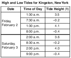
    Determine the altitude of Polaris at Kingston, New York, to the nearest degree. [1]

    °

    Allow 1 credit for 42°.

    Base your answers to questions 13 on the map in image provided and on your knowledge of Earth science. The map shows surface air temperatures for some locations in the United States on a day in November. The 20°F, 30°F, 40°F, and 70°F isotherms are shown. Points A, W, X, Y, and Z represent locations on Earth’s surface. The air temperature at location A is shown.
    13

    Identify the air temperature at Watertown, New York. [1]

    ______________ °F

    Allow 1 credit for any value from 39°F to 41°F.

    Base your answers to questions 14 on the partial geologic map in image provided and on your knowledge of Earth science. The map shows the geographical distribution of most of the Devonian-age surface bedrock in New York State.
    14

    On the map in the image provided, place an X at a location where the gastropod fossil Platyceras might be found in the surface bedrock. [1]

    reference-tables, generalized-bedrock-geology-of-new-york-state, earth-history, earth-history, relative-age-and-sequence-of-rock-strata, standard-6-interconnectedness, models fig: esci62013-ansbk_abkq1.png

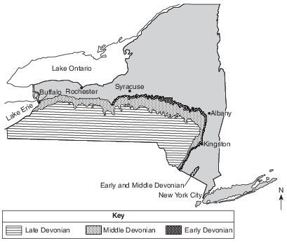
    Allow 1 credit if the center of the X is within the Middle Devonian zone or the Early and Middle. Devonian zone located northwest of New York City.

    Base your answers to questions 15 on the diagram below and on your knowledge of Earth science. The diagram represents a time-exposure photograph taken by aiming a camera at Polaris in the night sky and leaving the shutter open for a period of time to record star trails. The angular arcs (star trails) show the apparent motions of some stars.

    seasons-and-astronomy, earth-rotation, standard-6-interconnectedness, systems-thinking, standard-6-interconnectedness, models, standard-6-interconnectedness, patterns-of-change fig: esci62015-exam_g37.png

    15

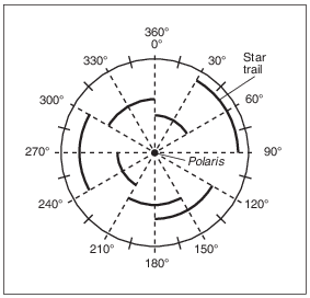
    Record, to the nearest whole degree, the altitude of Polaris when it is viewed from the top of New York State’s Mt. Marcy. [1]

    °

    Allow 1 credit for 44°.

    • Note: Do not allow credit if a compass direction is given (e.g., 44 N or 44° N) because that

    • denotes latitude, not altitude.