
Topic: Generalized Landscape Regions Of New York State
Generalized Landscape Regions Of New York State
During the month of January, at which location in New York State is the Sun lowest in the sky at solar noon?
(1) Massena
(2) Niagara Falls
(3) Utica
(4) New York City
Which two cities are located in the Interior Lowlands?
(1) Elmira and Binghamton
(2) Riverhead and New York City
(3) Massena and Old Forge
(4) Buffalo and Watertown
The Tug Hill region of New York State is geologically classified as a plateau because this region has relatively
(1) high elevation and deformed bedrock
(2) low elevation and deformed bedrock
(3) high elevation and horizontal bedrock
(4) low elevation and horizontal bedrock
Which New York State landscape region is composed of mostly horizontal sedimentary bedrock and has a high elevation?
(1) Hudson Highlands
(2) Manhattan Prong
(3) the Catskills
(4) Taconic Mountains
The Genesee River flows across both the Allegheny Plateau and the Erie-Ontario Lowlands in New York State. This river flows
(1) northward, in the same general direction as the Hudson River
(2) northward, in the same general direction as the Niagara River
(3) southward, in the same general direction as the Hudson River
(4) southward, in the same general direction as the Niagara River
Which conclusion can be drawn from the pattern of fossils found in Earth’s rock record?
(1) Humans have existed for a longer period of time than dinosaurs.
(2) Complex land organisms have been replaced by simpler marine forms.
(3) Many species have existed in the past, and most have become extinct.
(4) Few life forms existed before the late Cretaceous period.
A plane traveling in a straight line from Watertown to Utica would fly over which landscape region?
(1) Tug Hill Plateau
(2) Adirondack Mountains
(3) St. Lawrence Lowlands
(4) Champlain Lowlands
A portion of the Generalized Landscape Regions of New York State map below shows the location of the Catskill Aqueduct that flows into the Kensico Reservoir, which supplies the residents of New York City with drinkable water.

Which sequence shows the order of landscape regions that are crossed as water flows through the Catskill Aqueduct?
(1) Allegheny Plateau, Hudson-Mohawk Lowlands, Taconic Mountains, Newark Lowlands
(2) Allegheny Plateau, Hudson-Mohawk Lowlands, Hudson Highlands, Manhattan Prong
(3) Atlantic Coastal Plain, Newark Lowlands, Hudson Highlands, Hudson-Mohawk Lowlands
(4) Atlantic Coastal Plain, Manhattan Prong, Hudson Highlands, Allegheny Plateau
Which cross section best represents a plateau landscape region?
(1) 
(2) 
(3) 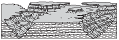
(4) 
The only dinosaur fossils found in New York State are footprints found on 210-million-yearold bedrock. In which New York State landscape region were these dinosaur fossils found?
(1) Tug Hill Plateau
(2) Newark Lowlands
(3) Allegheny Plateau
(4) Adirondack Mountains
In which landscape region are New York State’s Finger Lakes primarily located?
(1) Adirondack Mountains
(2) Allegheny Plateau
(3) Atlantic Coastal Plain
(4) Erie-Ontario Lowlands
Identify the name of the New York State landscape region where the greatest amount of snowfall occurred. [1]
Allow 1 credit for Tug Hill Plateau.
Identify the New York State landscape region where Cuba Lake is located. [1]
Allow 1 credit for Allegheny Plateau or Appalachian Plateau or Appalachian Uplands.
The Niagara Escarpment
A prominent feature found along the shore of Lake Ontario in western New York State is the Niagara Escarpment. This escarpment is the remains of an ancient seabed that was formed when the area was covered by a warm, shallow sea from approximately450 to 430 million years ago. Erosion of the Taconic Mountains to the east provided
the sediments deposited in this basin area. From these sediments, rock layers such as shale, sandstone, and limestone formed. Later, magnesium replaced some of the calcium in the top layer of limestone, turning it into a dolostone layer. When the high ocean levels of the Ordovician Period dropped, the draining of this inland sea caused unequal erosion of the exposed layers. The South Moraine was deposited on the top of the Niagara Escarpment in this region.
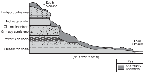
Identify the New York State landscape region in which the Niagara Escarpment is located. [1]
Allow 1 credit for Erie-Ontario Lowlands, or Erie-Ontario Plains, or Interior Lowlands.
Identify the name of the New York State landscape region where the river at point C is located. [1]
Allow 1 credit for Allegheny Plateau or Appalachian Plateau (Uplands).