Earth Science worksheet
    Topic: Inferred Properties Of Earth Interior
    Inferred Properties Of Earth Interior
    Base your answers to questions 1 on the cross section below and on your knowledge of Earth science. The cross section shows the boundary between the Juan de Fuca Plate and the North American Plate.

    reference-tables, tectonic-plates, dynamic-earth, plate-tectonics, standard-1-math-and-science-inquery, changing-length-of-a-shadow-based-on-the-motion-of-the-sun, standard-6-interconnectedness, models fig: esci82019-examw_g23.png

    (Not drawn to scale)

    1

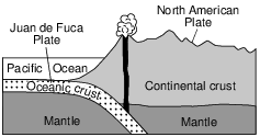
    Compared to the crust of the North American Plate, the crust of the Juan de Fuca Plate is

    (1) thicker and less dense

    (2) thicker and more dense

    (3) thinner and less dense

    (4) thinner and more dense

    2

    The pressure at the interface between Earth’s outer core and inner core is inferred to be

    (1) 0.2 million atmosphere

    (2) 1.5 million atmospheres

    (3) 3.1 million atmospheres

    (4) 3.6 million atmospheres

    Base your answers to questions 3 on the diagram and graph below and on your knowledge of Earth science. The diagram represents a portion of Earth’s interior. Letters A, B, and C represent interior layers. The graph shows the velocity of P-waves and S-waves at various depths in Earth’s interior.

    reference-tables, inferred-properties-of-earth-interior, dynamic-earth, earth-dynamic-interior, standard-1-math-and-science-inquery, changing-length-of-a-shadow-based-on-the-motion-of-the-sun, standard-6-interconnectedness, models fig: esci82018-examw_g39.png

    3

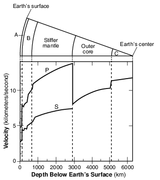
    Which layers of Earth’s interior are represented by letters A and B?

    (1) A is the crust and B is the rigid mantle.

    (2) A is the lithosphere and B is the asthenosphere.

    (3) A is the asthenosphere and B is the crust.

    (4) A is the rigid mantle and B is the lithosphere.

    4

    Earth’s interior at a depth of 3500 kilometers is believed to be

    (1) liquid at a temperature of approximately 4900°C

    (2) solid at a temperature of approximately 4900°C

    (3) liquid at a temperature of approximately 5400°C

    (4) solid at a temperature of approximately 5400°C

    5

    The diagram below represents a model of Earth’s surface and internal structure. Letters A, B, C, and D represent four different layers. Some depths below Earth’s surface are shown.

    reference-tables, inferred-properties-of-earth-interior, dynamic-earth, earth-dynamic-interior, standard-1-math-and-science-inquery, changing-length-of-a-shadow-based-on-the-motion-of-the-sun fig: esci82014-examw_g5.png

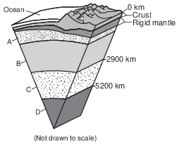
    Which Earth layer is inferred to be composed of solid nickel and iron?

    (1) A

    (2) B

    (3) C

    (4) D

    6

    Earth’s crustal bedrock at the Mid-Atlantic Ridge is composed mostly of

    (1) basalt, with a density of 2.7 g/cm3

    (2) basalt, with a density of 3.0 g/cm3

    (3) granite, with a density of 2.7 g/cm3

    (4) granite, with a density of 3.0 g/cm3

    7

    The cross section below represents several rock units within Earth’s crust. Letter A represents Earth’s surface. Letters B, C, and D indicate boundaries between rock units. One of the unconformities is labeled.

    reference-tables, inferred-properties-of-earth-interior, earth-history, earth-history, relative-age-and-sequence-of-rock-strata, standard-1-math-and-science-inquery, changing-length-of-a-shadow-based-on-the-motion-of-the-sun, standard-6-interconnectedness, systems-thinking, standard-6-interconnectedness, models fig: esci62015-exam_g16.png

    Which lettered boundary is most likely another unconformity?

    (1) A

    (2) B

    (3) C

    (4) D

    8

    In which Earth layer does the pressure reach 3.5 million atmospheres?

    (1) crust

    (2) stiffer mantle

    (3) outer core

    (4) inner core

    9

    What is the inferred pressure, in millions of atmospheres, in Earth’s interior at a depth of2900 kilometers?

    (1) 1.4

    (2) 9.9

    (3) 3.0

    (4) 4900

    10

    Most ozone is found in a region of Earth’s atmosphere between 10 and 20 miles above Earth’s surface. This temperature zone of the atmosphere is known as the

    (1) thermosphere

    (2) mesosphere

    (3) stratosphere

    (4) troposphere

    Base your answers to questions 11 on the map below and on your knowledge of Earth science. The map shows an enlargement of a portion of the Tectonic Plates map from the Physical Setting/Earth Science Reference Tables. Arrows showing plate motion have been omitted. Points Y and Z represent locations on plate boundaries.

    reference-tables, tectonic-plates, dynamic-earth, plate-tectonics, standard-1-math-and-science-inquery, changing-length-of-a-shadow-based-on-the-motion-of-the-sun, standard-6-interconnectedness, models fig: esci82018-examw_g56.png

    11

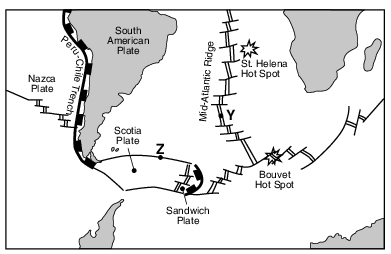
    The cross section in the image provided represents a portion of Earth’s interior beneath point Y. On this cross section, draw an arrowhead on each of the four bold lines, to represent the direction of the convection currents in the asthenosphere. [1]

    reference-tables, inferred-properties-of-earth-interior, dynamic-earth, earth-energy-density-and-movement-of-plates, standard-1-math-and-science-inquery, changing-length-of-a-shadow-based-on-the-motion-of-the-sun, standard-6-interconnectedness, models fig: esci82018-ansbk_abkq5.png

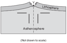
    Allow 1 credit for four arrowheads/arrows that indicate rising currents and a divergent movement in the asthenosphere.

    • Example of a 1-credit response:

    reference-tables, inferred-properties-of-earth-interior, dynamic-earth, earth-energy-density-and-movement-of-plates, standard-1-math-and-science-inquery, changing-length-of-a-shadow-based-on-the-motion-of-the-sun, standard-6-interconnectedness, models fig: esci82018-rg2_g6.png

    • Note: If additional arrowheads or arrows are drawn, all must be correct to receive credit.

    • If a student draws his/her own arrows, all arrows must indicate a correct rising and diverging movement.

    Base your answers to questions 12 on the cross sections below and on your knowledge of Earth science. The cross sections represent three different stages in the development of Denali (Mt. McKinley) and the growth of the North American Plate in Alaska near the boundary with the Pacific Plate. Arrows represent the direction of plate movement.

    reference-tables, tectonic-plates, dynamic-earth, plate-tectonics, standard-1-math-and-science-inquery, changing-length-of-a-shadow-based-on-the-motion-of-the-sun, standard-6-interconnectedness, models fig: esci62017-exampwr_g38.png

    12

    State the average density of the continental crust of the North American Plate and the average density of the oceanic crust of the Pacific Plate. [1]

    North American Plate continental crust: ____________ g/cm3 Pacific Plate oceanic crust: ____________ g/cm3

    Allow 1 credit if both responses are correct.

    • North American Plate continental crust: 2.7 g/cm3. Pacific Plate oceanic crust: 3 or 3.0 g/cm3

    Base your answers to questions 13 on the data table below, on the graph in the image provided, and on your knowledge of Earth science. The data table shows the velocity of seismic S-waves at various depths below Earth’s surface. The graph shows the velocity of seismic P-waves at various depths below Earth’s surface. Letter A is a point on the graph.

    dynamic-earth, earth-dynamic-interior, standard-6-interconnectedness, models fig: esci62014-examw_g47.png

    13

    State the pressure and temperature of Earth’s interior at the depth indicated by point A on the graph. [1]

    Pressure:

    °C Interior temperature:

    Allow 1 credit if both responses are correct.

    • Pressure: any value from 0.7 million atmospheres to 0.9 million atmospheres.

    • Interior temperature: any value from 4100°C to 4300°C.

    Base your answers to questions 14 on the passage and map below, and on your knowledge of Earth science. The map of the northwestern United States shows the location of the Columbia River Basalts.

    Columbia River Basalts

    The Columbia River Basalts are a formation of several horizontal lava fl ows from eruptions that took place between 6 million and 17 million years ago. These fl ows covered a portion of the northwestern United States. The lava erupted from cracks in Earth’s surface and fl owed westward toward the Pacifi c Ocean. These horizontal basalt layers are currently about 1200 meters above sea level. The lava was created when the North American Plate moved over a mantle hot spot.

    geologic-history, reference-tables, earth-history, earth-history, geologic-time-units-and-the-events, standard-1-math-and-science-inquery, changing-length-of-a-shadow-based-on-the-motion-of-the-sun, standard-6-interconnectedness, models fig: esci82022-exam_g44.png

    14

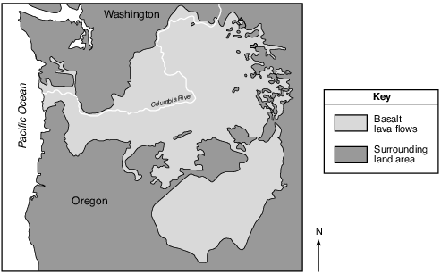
    The mantle plumes that created the lava fl ows of the Columbia River Basalts are inferred to have risen from the boundary between the stiffer mantle and the outer core. Identify the interior temperature and depth at this boundary. [1]

    Interior temperature: ______________ °C Depth: ______________ km

    Allow 1 credit if both responses are correct.

    • Interior temperature: any value from 4850°C to 5000°C

    • Depth: any value from 2850 to 2950 km

    Base your answers to questions 15 on the map below and on your knowledge of Earth science. The map shows the major islands in the Galapagos Island chain. These islands were formed by volcanic eruptions as the tectonic plate passed over the Galapagos Hot Spot. The age of the volcanic bedrock on certain islands is shown in millions of years (my).

    geologic-history, reference-tables, earth-history, earth-history, geologic-time-units-and-the-events, standard-6-interconnectedness, models fig: esci62013-examw_g52.png

    15

    Some of the magma at the Galapagos Hot Spot is believed to originate 1000 kilometers below Earth’s surface. What is the approximate temperature of Earth’s interior at that depth? [1]

    °C

    Allow 1 credit for any value from 3100°C to 3300°C.