
Topic: Jet Streams
Jet Streams
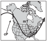
The map below shows a cold, arctic air mass that moved southeast from Canada to cover most of the eastern half of the United States during January 2010.
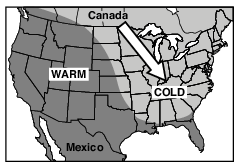
Which shift caused this flow of cold air out of Canada?
(1) the northward shift of the global temperature zones
(2) the northward shift of the Sun’s vertical rays
(3) a southward shift of the polar front jet stream
(4) a southward shift of the subtropical jet stream
The map below shows two seasonal positions of the polar front jet stream over North America.
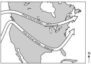
Which statement best explains why the position of the polar front jet stream varies with the seasons?
(1) Rising air compresses and cools in winter.
(2) Water heats and cools more rapidly than land in winter.
(3) Prevailing winds reverse direction in summer.
(4) The vertical rays of the Sun shift north of the equator in summer.
The map below shows a position of the polar jet stream over North America in January.
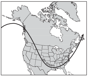
Which map best shows the air-mass movements associated with this jet stream position?
(1) 
(2) 
(3) 
(4) 
In which temperature zone of Earth’s atmosphere is the polar jet stream located?
(1) lower thermosphere
(2) lower mesosphere
(3) upper stratosphere
(4) upper troposphere
The diagram below shows the locations of the two major jet streams in Earth’s atmosphere.

Compared to the subtropical jet stream, the polar front jet stream is at a
(1) lower latitude and lower altitude
(2) lower latitude and higher altitude
(3) higher latitude and lower altitude
(4) higher latitude and higher altitude
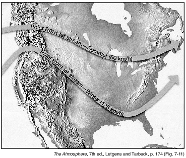
The map below shows a typical position and average velocity of the polar front jet stream during two different seasons.
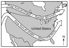
For the eastern United States, the change of the polar front jet stream from this summer position to this winter position causes
(1) warmer temperatures farther north and causes storms to move more slowly
(2) warmer temperatures farther north and causes storms to move more rapidly
(3) cooler temperatures farther south and causes storms to move more slowly
(4) cooler temperatures farther south and causes storms to move more rapidly
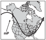
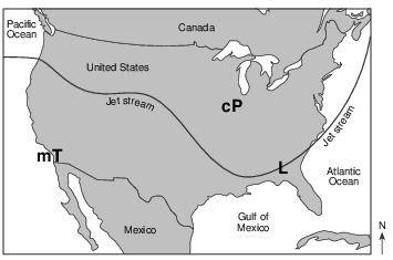
The map of North America below shows the position of the polar front jet stream on January 7, 2014, and the location of Atlanta, Georgia.

Which type of air mass was most likely located over Atlanta, Georgia?
(1) mT
(2) mP
(3) cT
(4) cP
Which diagram best represents the general position and direction of flow of the polar front jet stream in the Northern Hemisphere during the winter months?
(1) 
(2) 
(3) 
(4) 
The subtropical jet streams are fast flowing air currents located in the atmosphere about10 kilometers above the surface of Earth. In
which layer of the atmosphere are the subtropical streams located?
(1) stratosphere
(2) mesosphere
(3) troposphere
(4) thermosphere
In which layer of the atmosphere is this jet stream located?
(1) thermosphere
(2) mesosphere
(3) stratosphere
(4) troposphere
Jet stream winds over the United States generally move from
(1) east to west
(2) west to east
(3) north to south
(4) south to north
The map below shows the most likely positions and speeds of the polar front jet stream in summer and in winter.
In winter, the polar front jet stream has a more southerly path with winds traveling at speeds that are generally
(1) less than in summer, and Earth’s Northern Hemisphere tilts away from the Sun
(2) less than in summer, and Earth’s Northern Hemisphere tilts toward the Sun
(3) greater than in summer, and Earth’s Northern Hemisphere tilts away from the Sun
(4) greater than in summer, and Earth’s Northern Hemisphere tilts toward the Sun
Identify one factor that usually causes many low-pressure centers to generally move from west to east across the United States. [1]
Allow 1 credit. Acceptable responses include, but are not limited to:
• — the prevailing southwest winds
• — the jet stream
• — planetary winds