
Topic: Patterns Of Deposition And Formation Of Sedimentary Rocks
Patterns Of Deposition And Formation Of Sedimentary Rocks
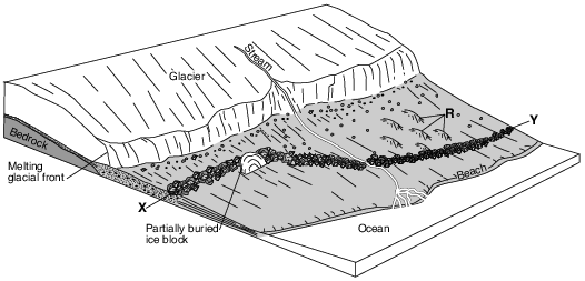
The ridge of sediments from X to Y can best be described as
(1) sorted and deposited by ice
(2) sorted and deposited by meltwater
(3) unsorted and deposited by ice
(4) unsorted and deposited by meltwater
The satellite photograph below shows the Mississippi River entering into the Gulf of Mexico. Arrows show the direction of river flow.
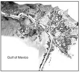
This depositional feature in the Gulf of Mexico is best identified as
(1) a delta
(2) a sandbar
(3) a barrier island
(4) an outwash plain
Roche Moutonée
A roche moutonée is a glacial landscape feature produced as an advancing glacier slides over a hill of surface bedrock. As the glacier advances up the side of the hill, the surface bedrock is abraded and smoothed by rock fragments carried within the base of the glacial ice, creating a more gentle hillslope. As the glacier advances down the opposite side of the hill, chunks of bedrock are broken off and removed by the ice, a process called glacial quarrying (plucking), making this side of the hill steeper. The resulting hill resembles a drumlin, except it is often smaller and is composed of solid bedrock.
A drumlin differs from a roche moutonée because a drumlin is
(1) formed by glaciers
(2) dome shaped
(3) deposited by glacial meltwater
(4) composed of loose sediments
Which diagram best represents sediments with the greatest degree of sorting by size?
(1) 
(2) 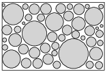
(3) 
(4) 
The photograph below shows a depositional feature located near the shore of Texas. Letter X represents a location on this feature.
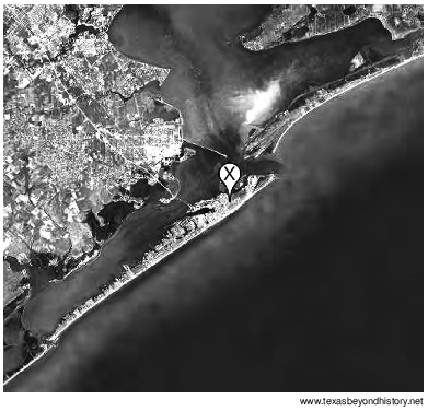
On which depositional feature is location X found?
(1) an island arc
(2) a barrier island
(3) a drumlin
(4) a floodplain
Pieces of bedrock material that are broken from a cliff and deposited by a landslide at the base of the cliff are best described as
(1) rounded and sorted
(2) rounded and unsorted
(3) angular and sorted
(4) angular and unsorted
An elongated hill that is composed of unsorted sediments deposited by a glacier is called
(1) a delta
(2) a drumlin
(3) a sand dune
(4) an outwash plain
When wind and running water gradually decrease in velocity, the transported sediments are deposited
(1) all at once, and are unsorted
(2) all at once, and are sorted by size and density
(3) over a period of time, and are unsorted
(4) over a period of time, and are sorted by size and density
The cross section below represents two types of sorted-sand depositional features found at a coastal location.
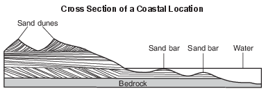
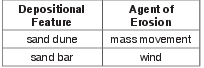
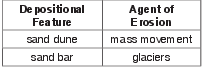
Which table correctly pairs these depositional features with the agents of erosion that formed them?
(1) 
(2) 
(3) 
(4) 


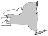
On the map in the image provided, place an X at the location where this rock sample was collected. [1]
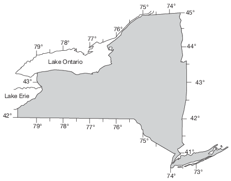
Allow 1 credit if the center of an X is placed within the circled area shown on the map below.
• Note: It is recommended that an overlay of the same scale as the student answer booklet be used
• to ensure reliability in rating.
• 
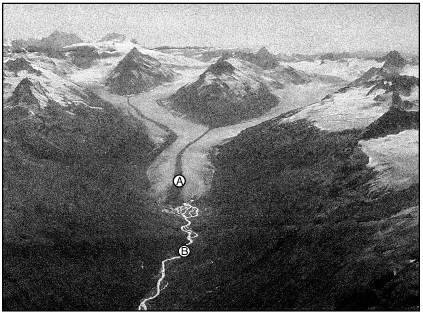
Describe the arrangement of sediments found within the moraine indicated by letter A. [1]
Allow 1 credit. Acceptable responses include, but are not limited to:
• — unsorted
• — unlayered
• — mixed

Identify the name of the depositional feature surrounding location A that is forming where the river enters the ocean. [1]
Allow 1 credit for delta or river delta.

Identify which point, X or Y, has more stream erosion and explain why the amounts of erosion are different. [1]
Point:
Explanation:
Allow 1 credit for X and a correct explanation. Acceptable explanations include, but are not limited to:
• — Point X is on the outside of a meander curve.
• — Stream velocity is greater at point X.
• — More deposition occurs at Y.

Identify the present-day feature that prevents the Allegheny River from returning to its earlier (Neogene) direction of flow to the northwest. [1]
Allow 1 credit. Acceptable responses include, but are not limited to:
• — glacial deposits
• — moraines
• — ridges of glacial sediments
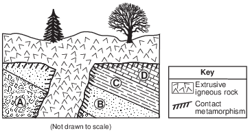
Describe one piece of evidence that suggests that rock layer C formed in a deeper sea environment than did rock layer A. [1]
Allow 1 credit. Acceptable responses include, but are not limited to:
• — The grain size of rock layer C is smaller.
• — Smaller sediment is deposited in deeper water.
• — Shale is made of clay-sized particles/clay.
• — Rock layer A contains larger sediments.