
Topic: Rock Cycle In Earth Crust
Rock Cycle In Earth Crust
The bedrock of the Adirondack Mountains was formed mainly by the
(1) cementation of clastic sediments and precipitates from seawater
(2) compaction and recrystallization of volcanic material
(3) regional metamorphism of sedimentary and igneous rocks
(4) contact metamorphism of unconsolidated gravels
Whiteface Mountain
Whiteface Mountain, located in the Mount Marcy region, is one of New York State’s highest mountain peaks. Most of the surface bedrock on Whiteface is anorthositic gneiss made up of large, light-colored plagioclase feldspar crystals and dark mineral bands composed of amphibole, pyroxene, and garnet. The foliated crystal alignment in the gneiss was produced during a major tectonic event called the Grenville orogeny. Landslides have exposed steep slopes of this white and gray bedrock on the sides of Whiteface Mountain.

The texture of the gneiss indicates that the bedrock
(1) underwent contact metamorphism
(2) underwent regional metamorphism
(3) was bioclastic in origin
(4) was composed of compacted sediment
The diagram below indicates physical changes that accompany the conversion of shale to gneiss.
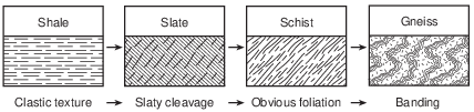
Which geologic process is occurring to cause this conversion?
(1) sedimentary layering
(2) intrusion of magma
(3) metamorphism
(4) weathering

The arrows in the block diagram below represent forces forming mountains in a region of Earth’s lithosphere.

Metamorphic rocks that formed from these forces are represented by which lettered box in the flowchart?
(1) A
(2) B
(3) E
(4) F
The photographs below show samples of two different rocks, labeled A and B. The arrow represents the process by which a rock like rock A can change into a rock like rock B.
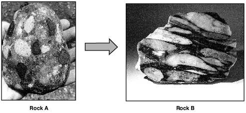
Which process does the arrow represent?
(1) metamorphism
(2) erosion
(3) melting
(4) cementation
Dinosaur Tracks Revealed After Years of Dry Weather
By April 2005, the surface of Lake Powell, a human-made lake in Utah and Arizona, had fallen 145 feet below its highest level. This revealed many traces of ancient life that had not been observed since this area had been covered with water. Among these traces, discovered in sandstone bedrock, were many dinosaur tracks, ranging in age between170 and 200 million years old.
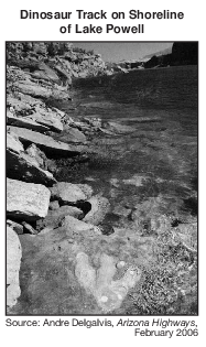
The events listed below led to the formation and exposure of these dinosaur tracks.
A. Rock layers above the dinosaur tracks are eroded.
B. Tracks are made in loose sand by dinosaurs.
C. Sediments are compressed and cemented.
D. Sedimentation buries tracks.
E. The water level of Lake Powell drops.
What is the correct sequence of the events listed above that led to the formation and exposure of the dinosaur tracks in the surface bedrock along the shoreline of Lake Powell?
(1) B → C → A → E → D
(2) B → D → C → A → E
(3) E → D → A → B → C
(4) E → C → B → D → A

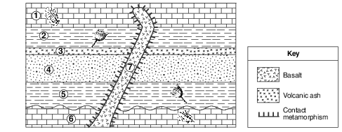
Which processes produced the brown siltstone layer in outcrops I and II?
(1) cooling and solidification of mafic lava at Earth’s surface
(2) cooling and solidification of felsic magma deep within Earth
(3) compaction and cementation of rock fragments ranging in size from 0.006 to 0.2 centimeter in diameter
(4) compaction and cementation of rock fragments ranging in size from 0.0004 to 0.006 centimeter in diameter
Diagrams A and B represent magnified views of the arrangement of mineral crystals in a rock before and after being subjected to geologic processes.

Which geologic processes are most likely responsible for the banding and alignment of mineral crystals represented in diagram B?
(1) melting and solidification
(2) heating and increasing pressure
(3) compaction and cementation
(4) weathering and erosion
The granite formation was primarily formed by
(1) metamorphism of layered sandstone
(2) solidification of felsic magma
(3) compaction of precipitated gypsum
(4) cementation of clastic sediments
Which rock was subjected to intense heat and pressure but did not solidify from magma?
(1) sandstone
(2) schist
(3) gabbro
(4) rhyolite

Slightly acidic groundwater has been seeping through cracks and openings in the limestone bedrock of this area, producing caves. State whether the type of weathering that produces these caves is mainly chemical or physical, and identify one characteristic of limestone that allows this type of weathering to occur. [1]
Type of weathering: Characteristic of limestone:
Allow 1 credit for chemical weathering and an acceptable characteristic of limestone. Acceptable characteristics include, but are not limited to:
• — Acid dissolves limestone.
• — The calcite in the limestone chemically reacts with acid.
• — Limestone is composed of calcite.

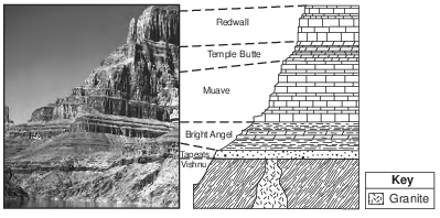
The Vishnu group is composed mostly of schist. Explain how this rock formed. [1]
Allow 1 credit. Acceptable responses include, but are not limited to:
• — Heat and pressure metamorphosed early rocks.
• — Regional metamorphism distorted these rocks.
• — heat and pressure
• — metamorphism
• Note: Do not allow credit for “contact metamorphism” because schist forms from regional
• metamorphism.
Identify one process that causes clouds to form in the moist air rising along the frontal boundaries of the low-pressure system. [1]
Allow 1 credit. Acceptable responses include, but are not limited to:
• — condensation
• — cooling
• — expansion
• — deposition/phase change directly from water vapor to ice
Unusual Volcano
Nyiragongo, located at 2° S 29° E, is an active African volcano. It has the most fluid lava on Earth. The lava has a composition unlike any other lava in the world. The rare isotopes found in the lava are similar to those found in ancient asteroids. This fact leads scientists to infer that the lava may be as old as our solar system and that it comes from deep inside the mantle near Earth’s outer core. Nyiragongo is one volcano in a ring of many volcanoes surrounding an area that is domed upward nearly a mile above sea level, causing scientists to infer that a new mantle hot spot is forming there.
Two rocks, scoria and basalt, have formed from the cooled lava that erupted from Nyiragongo. Describe the texture of each rock. [1]
Scoria:_____________________________________
Basalt: _____________________________________
Allow 1 credit for an acceptable response for both rocks. Acceptable responses include, but are not limited to:
• Scoria:
• — noncrystalline
• — glassy
• — vesicular
• Basalt:
• — fine
• — nonvesicular
Identify two processes that produced the basalt. [1]
and _____________________________
Allow 1 credit for two correct responses. Acceptable responses include, but are not limited to:
• — cooling
• — solidification
• — crystallization
• — melting
• — intrusion/intruding