
Topic: Surface Ocean Currents
Surface Ocean Currents
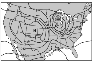
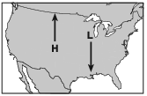
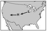
The arrows on which map show the most likely path in which these two pressure centers will move over the next few days?
(1) 
(2) 
(3) 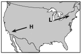
(4) 
Which ocean current brings warm water to the southeastern tip of Africa?
(1) Brazil Current
(2) Agulhas Current
(3) Guinea Current
(4) Benguela Current
What controls the direction of movement of most surface ocean currents?
(1) density differences at various ocean depths
(2) varying salt content in the ocean
(3) prevailing winds
(4) seismic activity
Which type of air mass would most likely form over the Pacific Ocean north of the Aleutian Trench?
(1) mP
(2) mT
(3) cP
(4) cT
Which current has a cooling effect on the climate of the west coast of South America?
(1) Falkland Current
(2) Peru Current
(3) Benguela Current
(4) Brazil Current
Which ocean current directly warms Western Europe?
(1) North Atlantic Current
(2) South Equatorial Current
(3) Canary Current
(4) Labrador Current
Which ocean current brings warm water to the southeastern coast of Africa?
(1) Agulhas Current
(2) Benguela Current
(3) West Australian Current
(4) Equatorial Countercurrent
Which current has a warming effect on the climate of the southeast coast of Africa?
(1) Guinea Current
(2) Falkland Current
(3) Benguela Current
(4) Agulhas Current
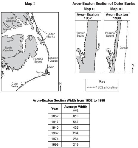
Which ocean current has the greatest warming influence on the climate of the Outer Banks of North Carolina?
(1) Gulf Stream Current
(2) North Atlantic Current
(3) Labrador Current
(4) Canary Current
Identify the name of the cool surface ocean current that influences the climate of this region. [1]
Allow 1 credit for California Current.
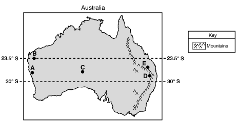
Identify the ocean current that most affects the climate of location A. [1]
Allow 1 credit for West Australia Current.
Coral Reefs and Ocean Currents
The location of shallow-water coral reefs is controlled largely by warm-water temperatures, which originate in tropical regions and are then widely spread by ocean currents. Major surface ocean currents flow in circular patterns called gyres. Ocean current gyres flow in a clockwise direction in the Northern Hemisphere, and flow in a counterclockwise direction in the Southern Hemisphere. This pattern of circulation generally moves warm water from equatorial regions into the shallow waters along eastern continental coasts. This extends the range of coral reef growth approximately 5° of latitude beyond both the tropic of Cancer and the tropic of Capricorn.
Identify the surface ocean current that prevents the formation of coral reefs in the shallow waters along the western coast of South America. [1]
Current
Allow 1 credit for Peru Current.

Identify the surface ocean current that affects the climate of Eureka. [1]
Current
Allow 1 credit for California Current.
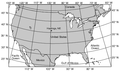
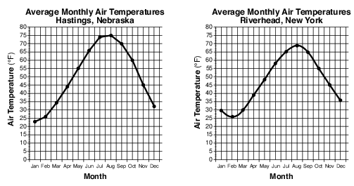
Name the ocean current that most likely has the greatest effect on the climate of Riverhead. [1]
Current
Allow 1 credit for Gulf Stream Current.
Mount Manaro Erupts!
Mount Manaro is a volcano on Ambae Island, about 1400 miles northeast of Australia. Ambae Island is located in the South Pacific Ocean at 15° south latitude, 168° east longitude.
After Mount Manaro had erupted in 1995, Ambae Island residents developed an evacuation plan. When Mount Manaro began erupting gas, steam, and ash on November 27, 2005, scientists and residents watched the volcano carefully.
The eruption became more severe on December 9, 2005, when steam and gases rose 1.8 miles up into the air. Rocks and ash began to fall on nearby farms and homes. Thousands of people left their homes, making it the largest evacuation ever on Ambae Island.
Identify the ocean current off the northeast coast of Australia that most affects the climate of Ambae Island. [1]
Allow 1 credit. Acceptable responses include, but are not limited to:
• — East Australia Current
• — South Equatorial Current
• — E. Australia C.