
Topic: Tectonic Plates
Tectonic Plates
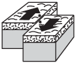
Which block diagram represents the plate motion that causes the earthquakes that occur along the San Andreas Fault in California?

(1) 
(2) 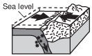
(3) 
(4) 
Which surface feature was produced by crustal movements at a transform plate boundary?
(1) East African Rift
(2) Aleutian Trench
(3) Tasman Hot Spot
(4) San Andreas Fault
Which two mantle hot spots are located at midocean ridges?
(1) Iceland and Yellowstone
(2) Galapagos and Tasman
(3) St. Helena and Hawaii
(4) Easter Island and Bouvet
Which tectonic feature is associated with a complex or uncertain plate boundary?
(1) Southwest Indian Ridge
(2) East African Rift
(3) Mariana Trench
(4) Galapagos Hot Spot
Which landmass is moving northward with Australia as part of the same tectonic plate?
(1) India
(2) Antarctica
(3) North America
(4) South America
Which mantle hot spot is correctly matched to its overlying tectonic plate?
(1) Tasman Hot Spot–Pacific Plate
(2) Canary Island Hot Spot–Eurasian Plate
(3) St. Helena Hot Spot–South American Plate
(4) Yellowstone Hot Spot–North American Plate
Shipwreck
In 1641, the crew of the ship Concepcion used the Sun and stars for navigation. The crew thought that the ship was just north of Puerto Rico, but ocean currents had carried them off course. The ship hit a coral reef and sank off the coast of the Dominican Republic. The X on the map marks the location of the sunken ship.
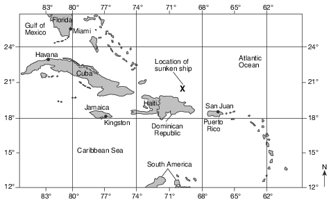
On which tectonic plate is Puerto Rico located?
(1) North American Plate
(2) South American Plate
(3) Caribbean Plate
(4) Cocos Plate
Mt. Redoubt Volcano
In Anchorage, Alaska, scientists are monitoring sensors located on nearby Mt. Redoubt. The sensors measure seismic activity at the top of the volcano. No one lives near the volcano itself, so there is no danger to humans from lava flows, but ash can be dangerous when breathed in, and can damage airplanes and automobiles if the ash is drawn into their engines. When Mt. Redoubt erupted in 1989, a huge ash cloud reached an approximate height of 7.6 miles above sea level, and spread ash across Alaska for five months. The ash was composed largely of silica, which cooled rapidly as the ash rose into the atmosphere. In March 2009, Mt. Redoubt erupted again.

Mt. Redoubt’s seismic activity is due to the interaction of which two tectonic plates?
(1) Pacific Plate and Eurasian Plate
(2) Eurasian Plate and North American Plate
(3) North American Plate and Pacific Plate
(4) Philippine Plate and Eurasian Plate
The formation of the Canary Islands was primarily caused by their location near a
(1) subduction zone
(2) mantle hot spot
(3) divergent boundary
(4) transform fault
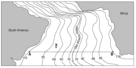
The Mid-Atlantic Ridge separates pairs of crustal plates, such as the South American Plate and the African Plate. Identify one other pair of crustal plates separated by the Mid-Atlantic Ridge. [1]
Plate and _____________________________ Plate
Allow 1 credit. Acceptable responses include, but are not limited to:
• — North American Plate and Eurasian Plate
• — N. American Plate and African Plate
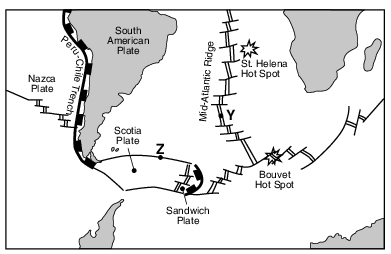
Identify the type of tectonic plate boundary found at location Z. [1]
Allow 1 credit. Acceptable responses include, but are not limited to:
• — transform boundary
• — transform fault
• — strike-slip fault
On February 27, 2010, a strong earthquake with a magnitude of 8.8 occurred off the west coast of South America near the city of Concepción in central Chile. There was tremendous damage to the region and loss of life, as buildings collapsed. Tremors were felt as far north as Ica, Peru, 2400 kilometers away. The earthquake triggered a tsunami that damaged several coastal towns. Tsunami warnings were issued to 53 countries, including the United States, where damage was reported. This earthquake is ranked as one of the highest in magnitude ever recorded by a seismograph. Chile has experienced some of the strongest earthquakes in the past, including a 1960 earthquake that had a magnitude of 9.5, the highest ever recorded.

Identify the name of the oceanic tectonic plate located along the west coast of South America where this earthquake occurred. [1]
Plate
Allow 1 credit for Nazca Plate.
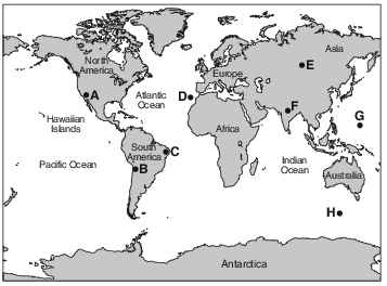
Identify the tectonic feature responsible for the formation of the Hawaiian Islands. [1]
Allow 1 credit. Acceptable responses include, but are not limited to:
• — Hawaii Hot Spot
• — mantle hot spot
• — volcano
• — a rising magma plume

Identify the names of the tectonic plates at locations A and B. [1]
Location A: Plate Plate Location B:
Allow 1 credit if both responses are correct.
• Location A: Nazca Plate
• Location B: South American Plate
Unusual Volcano
Nyiragongo, located at 2° S 29° E, is an active African volcano. It has the most fluid lava on Earth. The lava has a composition unlike any other lava in the world. The rare isotopes found in the lava are similar to those found in ancient asteroids. This fact leads scientists to infer that the lava may be as old as our solar system and that it comes from deep inside the mantle near Earth’s outer core. Nyiragongo is one volcano in a ring of many volcanoes surrounding an area that is domed upward nearly a mile above sea level, causing scientists to infer that a new mantle hot spot is forming there.
Identify the type of tectonic plate boundary found in the vicinity of Nyiragongo. [1]
Allow 1 credit. Acceptable responses include, but are not limited to:
• — an uncertain or complex plate boundary
• — a divergent plate boundary
• — rift valley/East African Rift