
Topic: Weathering Soils
Weathering Soils
Early in its formation, Earth was a molten mass of evenly mixed composition. During the next few million years, the heavier and more dense elements sank to the center, while lighter and less dense elements rose toward the surface. This is called chemical fractionation.

Chemical fractionation is most likely caused by
(1) solidification
(2) gravity
(3) magnetic force
(4) chemical weathering
A cross section of Niagara Falls is shown below.
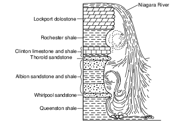
Which two rock units appear to be most resistant to weathering and erosion?
(1) Lockport dolostone and Whirlpool sandstone
(2) Rochester shale and Albion sandstone and shale
(3) Clinton limestone and shale and Queenston shale
(4) Thorold sandstone and Queenston shale
Which rock weathers most rapidly when exposed to acid rain?
(1) quartzite
(2) granite
(3) basalt
(4) limestone
Lichens are usually the first organisms that appear in barren, rocky areas. They use rootlike structures to split bedrock into small fragments. Lichens also secrete acidic solutions that help break down rock. The cross sections below represent an area when lichens first appeared (time 1) and that same area hundreds of years later, after it was changed by lichens and exposed to air and water (time 2).
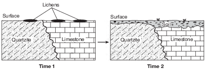
The soil shown in time 2 was formed mainly by
(1) compaction and cementing
(2) weathering and biological activity
(3) faulting and tilting of rock strata
(4) mass movement and deposition of particles
Roche Moutonée
A roche moutonée is a glacial landscape feature produced as an advancing glacier slides over a hill of surface bedrock. As the glacier advances up the side of the hill, the surface bedrock is abraded and smoothed by rock fragments carried within the base of the glacial ice, creating a more gentle hillslope. As the glacier advances down the opposite side of the hill, chunks of bedrock are broken off and removed by the ice, a process called glacial quarrying (plucking), making this side of the hill steeper. The resulting hill resembles a drumlin, except it is often smaller and is composed of solid bedrock.
The formation of a roche moutonée by glaciers is best described as an example of
(1) chemical weathering
(2) physical weathering
(3) sediment deposition
(4) mass movement
The weathering of four different rock samples with different masses was studied. Each rock sample was placed in a separate beaker containing 500 milliliters of a dilute acid for 10 minutes. Bubbling was observed in some of the beakers. The data table below shows the mass of each sample, in grams, before placement in the acid and after removal from the acid.
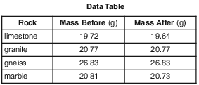
Which Earth process is being modeled in this experiment?
(1) physical weathering in the hydrosphere
(2) physical weathering in the mesosphere
(3) chemical weathering in the hydrosphere
(4) chemical weathering in the mesosphere
The block diagram below represents caves that developed in a region over time.

Which type of weathering was primarily responsible for the development of these caves?
(1) physical weathering of sandstone
(2) physical weathering of limestone
(3) chemical weathering of sandstone
(4) chemical weathering of limestone
The two block diagrams below represent the formation of caves.

Which types of weathering and erosion are primarily responsible for the formation of caves?
(1) chemical weathering and groundwater flow
(2) chemical weathering and runoff
(3) physical weathering and groundwater flow
(4) physical weathering and runoff
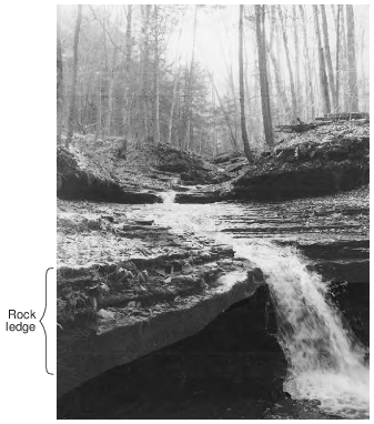
Compared to the bedrock layers above and below the rock ledge shown at the waterfall, the characteristic that is primarily responsible for the existence of the rock ledge is its greater
(1) resistance to weathering
(2) abundance of fossils
(3) thickness
(4) age
The cross section below represents an outcrop of sedimentary rock layers exposed on Earth’s surface. Rock layers A, B, C, and D are labeled.
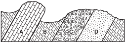
Which rock layer shows the greatest resistance to weathering and erosion?
(1) A
(2) B
(3) C
(4) D
The cross section below represents zones of soil labeled A, B, and C. Letter D represents underlying bedrock.

Which letter identifies the zone having the most organic and weathered material?
(1) A
(2) B
(3) C
(4) D

Slightly acidic groundwater has been seeping through cracks and openings in the limestone bedrock of this area, producing caves. State whether the type of weathering that produces these caves is mainly chemical or physical, and identify one characteristic of limestone that allows this type of weathering to occur. [1]
Type of weathering: Characteristic of limestone:
Allow 1 credit for chemical weathering and an acceptable characteristic of limestone. Acceptable characteristics include, but are not limited to:
• — Acid dissolves limestone.
• — The calcite in the limestone chemically reacts with acid.
• — Limestone is composed of calcite.
Meteorite Composition
Meteors that strike Earth’s surface are called meteorites. Analysis of meteorite composition has provided scientists with information regarding the formation of Earth and our solar system, and possibly the development and evolution of life on Earth.
Two types of meteorites are iron meteorites and chondrites. Iron meteorites consist mostly of iron and nickel, and are inferred to be from core materials of early planetary bodies in our solar system. More than 60% of meteorites studied have been identified as chondrites. Chondrites are made of millimeter-sized spheres of olivine and pyroxene crystals embedded in a mass of mineral and metal grains. The chondrites are thought to represent fragments of the earliest solid materials in our solar system. One type of chondrite, the carbonaceous chondrite, contains water, organic compounds, and minerals that represent the chemical composition necessary for life to form.
Explain why there is little evidence of meteorite impact craters on Earth. [1]
Allow 1 credit. Acceptable responses include, but are not limited to:
• — Weathering and erosion on Earth’s surface have erased many craters.
• — Most meteors are very small and burn up in Earth’s atmosphere.
• — Most of Earth’s surface is ocean, where sediments cover impact craters.
• — Crustal plate movement has destroyed the evidence.
Excerpt from Inca Gold
…The sinkhole’s early history began in the Cambrian era when the region was part of an ancient sea. Through the following geological eras, thousands of generations of shellfish and coral lived and died, their skeletal carcasses forming an enormous mass of lime and sand that compressed into a limestone and dolomite layer two kilometers thick. Then, beginning sixty-five million years ago, an intense earth uplifting occurred that raised the Andes Mountains to their present height. As the rain ran down from the mountains it formed a great underground water table that slowly began dissolving the limestone. Where it collected and pooled, the water ate upward until the land surface collapsed and created the sinkhole.…


Describe the chemical weathering that contributes to the formation of sinkholes. [1]
Allow 1 credit. Acceptable responses include, but are not limited to:
• — The acid in water chemically reacts with the carbonates in the rocks.
• — Limestone is chemically altered and changed into new materials.
• — Slightly acidic groundwater chemically breaks down calcite and/or dolomite.
• — Water flowing underground dissolves the limestone.
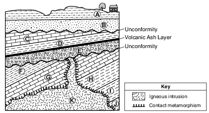
Identify two processes that most likely caused the formation of both unconformities. [1]
(1) (2)
Allow 1 credit for two correct responses. Acceptable responses include, but are not limited to:
• — uplift/emergence/tilting/folding
• — erosion
• — submergence/subsidence
• — weathering
• — deposition
• — burial